AN OFFSHORE PARADISE
See also: www.barbudaful.net

![]()
![]()
| BARBUDA |
AN OFFSHORE PARADISE
|
HOME PAGE See also: www.barbudaful.net |
|
|
|
![]()

![]()
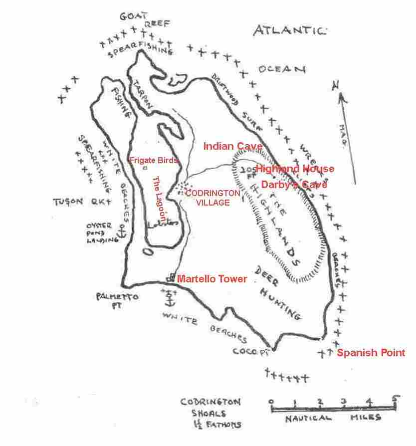
Just 27 miles north of Antigua and 62 miles square, at 17.5º N by 61.35º W, the island is about 14 miles long by 8 miles wide. The highest point is only about 125 ft. The population in 2001 was 1,417 of which there were 748 males and 669 females. The longest beach (on the west side) is 12 miles long.
Barbuda presents a vista of shimmering beaches of white and pink sands lapped softly by crystal clear waters of iridescent turquoise. The beaches are fabulous, stretching unbroken and unpopulated to the horizon. They are seemingly endless are left to the peaceful wanderings of those lucky enough to sojourn there.
It is a fascinating island to visit in many ways, abundant and varied in its marine and bird life, notably thousands of magnificent Frigate Birds, seen at the sanctuary, and it still has its share of wild boar and Fallow Deer.
Barbuda is one of those very few islands in the Caribbean that remains--and probably will remain for some time--so undeveloped as to seem positively deserted at times. Activities on Barbuda are appropriately relaxed, including beachcombing (on the northeastern Atlantic coast), fishing and hunting and, at the island's resorts, golf, tennis, snorkeling, diving, or simply soaking up the sun and the calm. Points of interest include the Frigate Bird Sanctuary, the truly noteworthy pink and white sand beaches, and an abundance of shipwrecks and beautiful reefs. Natural sites are Indian Cave, Darby's Cave and a historical site is at the Martello Tower (River). Barbuda can be reached easily from Antigua, either by air (a 20-minute flight, twice daily) or by boat (in three hours). The island is home to the luxurious K-Club, Coco Point Lodge and Hotel Palmetto resorts, as well as to a number of other hotels and comfortable guest houses. For hotels see http://www.interknowledge.com/antigua-barbuda
Barbuda's history has been intimately tied to that of Antigua for centuries. The first early attempts to settle Barbuda (by both the British and French) were failures, and it wasn't until 1666 that the British established a colony strong enough to survive the ravages of both nature and the Amerindians originally from South America, attempting to keep the Europeans off their islands.
In 1685, Christopher and John Codrington were granted a lease of Barbuda for 50 years in exchange for "One fat sheep on demand". With subsequent leases that granted them additional rights to the substantial wreckage along Barbuda's reefs, they became the island's preeminent family. For much of the eighteenth century the Codrington land on Barbuda was used to produce food and to supply additional slave labour for the Codrington sugar plantations on Antigua, and so the fortunes of Barbuda rose and fell with those of its larger neighbour. Testament to the influence of the Codringtons remains today, both in the island's place names and in its architectural remains. On Barbuda's highest point (125 feet) are the ruins of the Codrington estate, Highland House, and on the island's south coast still sits the 56-foot high Martello tower and fort, a fortress that was used both for defense and as a vantage from which to spot valuable shipwrecks on the outlying reefs.
A WORD ABOUT NAMES - The Amerindian name for Barbuda was "Wa'omoni", as seen in Father Raymond Breton's Island Carib Dictionary. This is thought to mean the "Island of Herons". Since the word could mean any large bird, it could possibly cover the Frigate or Weather Bird, so common in Barbuda.
In 1529, Diego Ribero named Barbuda in his early map of the Caribbees as "La Barbuda" and Antigua "Elagua". Another geographer, Cabot, called it "Baruada". Then Descelius' map of the Indies (1546) shows Barbuda as "Barnada". Zaltieri's map of 1566 calls the island "Las Barbuda".
Historians in both Antigua and Barbuda and Barbados have no real solution to the origin of the names of these islands. Legend has it that both Barbuda and Barbados mean "bearded". This may refer to the occurrence either of bearded Indians that were found there or to the Wild Fig (Ficus sp.), which has a bearded appearance with its aerial roots dropping from lower branches. The latter is more likely explanation. In Sebastian Cabot's map of 1544, both islands, and these only in the Eastern Caribbean have curious dots around them, and believed by some to represent reefs. So it may be that foaming breakers may have reminded early explorers of islands with beards. Take your pick on the origin of the name!
In 1628, settlers
from St. Kitts knew
Barbuda as "Dulcina"
for its "excellence
and pleasantnesse
thereof", but it
soon reverted back
to the name Barbuda.
Barbuda has its
share of names
attributed to
natural features and
to its flora and
fauna. Examples are
Two-foot Bay, Pigeon
Cliff, Pelican Bay,
Palmetto Point,
Oyster Pond,
Cedar-tree Point,
Goat Island, Kid
Island, Hog Point
and Tobacco Gut.
There are several
local names of a
picturesque nature,
as Tumbly Wood,
Found Out, Spiney
Hill Perk, Picus
Well, Kakie Hill,
Boney Mangrove, Box
Cape and Benter
Will.
CODRINGTON VILLAGE (History).
The only settlement of Barbuda is named after the Codrington family that leased Barbuda 185 years from 1685 until 1870. In 1904, the village boundaries were set to the west by the lagoon, to the north by Sedge Garden, to the east by Indigo Piece and to the south by the Park. The population at that time was 700 and by the 1991 census this had increased to 1,252.
Old maps show Codrington dominated by the Castle used as a strong and secure place against Amerindian and French raids. It was rectangular with watchtowers at the northeast and southwest corners with stonewalls and embrasures. In the courtyard were the overseer's house and a well. A slave uprising occurred in 1745 when Mr. McNish, a one time manager, was killed because he had been mutilating imprisoned slaves in the Castle for stealing sheep and cattle. Slaves soon occupied the castle and took possession of arms and ammunition. Soldiers then arrived from Antigua to put down the rebellion, after which two of slaves (forgotten Afro heroes?) were burned alive at the main gate of the Castle. No traces of the walls remain today, the castle was badly damaged in the great earthquake of 1843.
BARBUDA FRIGATE
BIRD NESTING COLONY
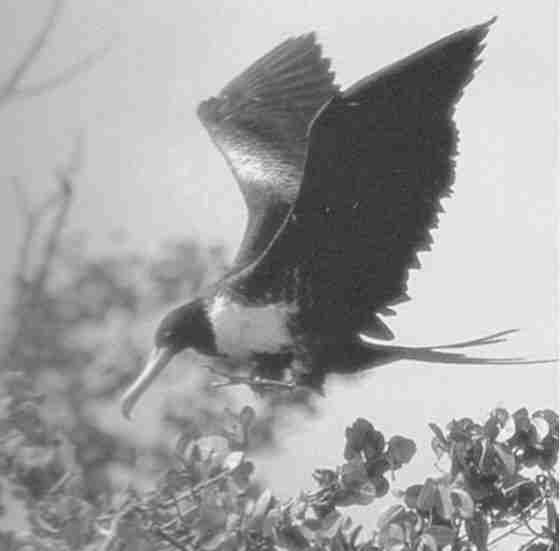
Probably the most valued asset to Barbuda's tourism, second only to the white sand beaches over 10 miles long, is the Frigate Bird Colony. This is towards the north end of the lagoon in a mangrove locality, a significant nesting colony of the gracefully flying Frigate Bird (Fregata magnificans) may be visited. It is said to be the largest Frigate Bird gathering in the world, with an estimated 2,500, (1971). There may be no more than 25 nesting sites in the Caribbean today.
Frigate Bird Facts:
They are relatives of pelicans, cormorants and boobies.
Males are glossy black, females have white breasts, the immature have white heads and necks.
Males blow up a scarlet throat sac the size of a balloon, taking about 25 minutes, to attract a female mate. When one appears, the wings are trembled showing the under surface, flashing in the sunlight and drumming sounds are emitted.
The wing span is 8 ft. and a body weight of 3 lb. Flight speed, 22 mph.
A 2,000 ft. altitude is common.
Frigates cannot take off from the sea or from the ground.
They feed on fish from Barbuda's lagoons and interior ponds. Also flying fish, jelly fish and small turtles taken from the ocean.
Adults chase other sea birds to grab their catch, hence the names, Frigate Bird and Man-o-War Bird.
In a colony there are three twig nests average, in an area 9x12 ft.
The colony is a contentious place where birds argue over landing rights, perch ownership or who owns each nest twig!
One male and three females produce two young every two years.
One white egg is laid sometime between mid-September to late March. Incubation is seven weeks.
The young are fed by regurgitation. They fly about 25 weeks after hatching. Six years before first breeding.
The oldest known age is 34 years.
Darby’s Cave is
perhaps the most
interesting natural
feature of Barbuda.
It is not a true
cavern but a
vertical sided sink
hole formed by
solution below
ground and
subsequent
collapse. One side
of the sink hole is
undercut by a full
30 ft. hence the
name “cave”. The
cliffs are about 70
ft high and the hole
is about 350 ft in
diameter.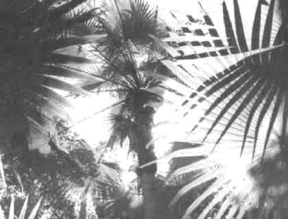
The cave possesses very lush vegetation, full of tall trees, the commonest of which is the palmetto palm once used by Barbudans for many purposes. Over the cliff’s rim descend hawser thick roots of mighty lianas. The lianas interlace the trees, ferns cluster on the damp soil and birds are abundant; the scene is reminiscent of a tropical rain forest. This is uch a contrast to the surrounding dry bush land.
From the overhang of the cliff there is an intermittent drip of water, which, in time, has created stalagmites of calcium, There is a startlingly large flat-topped stalagmite eight feet high and not less than two feet in diameter. This greenish white, almost translucent, mass of limestone is so smooth and solid that it would be difficult to find its counterpart in any other part of the world. A fossilised part of an upper shark's tooth of a pliocene (2-4 million years ago) species (Carcharodon megalodon) was been found in the limestone of the cave in May 1997.
By far the most interesting prehistoric site in Barbuda is the cave at Two Foot Bay, a wild windswept part of northeast Barbuda. The entrance to this cave is close to a roofless stone ruin near the shore. It was probably a house associated with the phosphate mining operation undertaken at Gun Shop Cliff in the 1890’s.
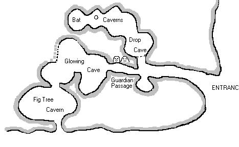
Indian Cave is small, though a neat complex. Giving a mysterious feeling, it is not difficult to imagine the Amerindians having lived here long ago. The cave’s outlook is along the north-eastern windward coast. It may have been a lookout for a large Amerindian village site that is close at hand.
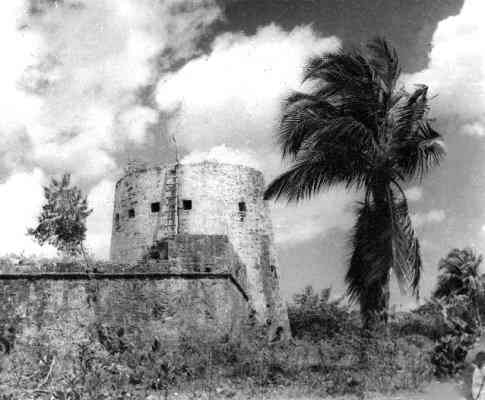
MARTELLO TOWER, (c. 1745 - c. 1850).
This tower, 32 feet high, and fort of 3 guns was used as a look-out along the south coast and for sighting in-coming or wrecked ships. This information was then signalled onward to the village of Codrington, several miles north..
The fort, once with 3 guns, is
placed near a small
river which only
appears in times of
wet weather. This
small stream is
caused by the
drainage of swamps
that lie inland
behind the beach.
The fort guarded the
main anchorage on
the south-western
side of Barbuda.
The name 'Martello'
is derived from a
tower at Cape Mortella in Corsica
that the British,
had difficulty in
taking in 1794. The
south coast of
England was defended
by Martello Towers
against Napoleon's
intended invasion of
England in 1803.
HIGHLAND HOUSE, (c. 1720).
The Barbudans know
this locality as "Willybob".
This may have been
derived from a
corruption of
William Codrington,
a former owner. The
Codringtons built
Highland house
sometime after 1720
on the Highlands of
Barbuda, which is
about 125 ft. above
sea level. It is
also the highest
point of Barbuda.
Other names
connected with
Highland House have
been found
archaeologically. A
bottle seal from the
side of a bottle
bearing the name of
Col. John Gunthorpe
was found amongst
the ruins of
Highland House.
Interestingly
enough, William Byam,
who leased Barbuda
from 1746 until
1762, married Anne
Gunthorpe, the
daughter of John in
1735. So it may be
that Byam was given
a bottle of wine by
his father-in-law!
It certainly
connects Byam with
Highland House. It
is also known from a
letter of the period
that William Byam
built some wooden
bedrooms near the
dwelling house at
Highland House.
SPANISH POINT
Spanish Point,
studded with coral
reefs, is the most
southeasterly point
of Barbuda and is
perhaps named after
the wreck of a
Spanish merchantman
by the name of
"Santiago de
Cullerin". She was
lost here in 1695,
and indeed, shortly
afterwards maps
began to appear with
the name of Spanish
Point. She was
carrying 13,000
pesos to pay Spanish
garrisons at
Maracaibo, on the
Spanish Main, but
all this and some of
her other cargo was
salvaged by divers
at the time. In
1988, the dive ship
"Riptide" of H & E
Marine, began
mapping the site and
recovered a few
artifacts from under
a thick coral
concretion in heavy
surf on the windward
side. No coins were
found, but large
jars and a wooden
comb are some of the
many artifacts
recovered.
The Point's history
had begun much
earlier, for
maritime Amerindians
from South America
had settled in the
vicinity about 500
years after the
birth of Christ.
Then later, European
colonists built a
small lookout tower,
probably as a
precaution against
marauding
Amerindians from
Dominica who at the
time were jealous of
the European
incursion.
Last updated - 9 March 05 To TOP